Today, two weeks after Hurricane Helene it is hard to comprehend the scope, scale, and fury of the storm that hit western North Carolina, East Tennessee, the Upstate in South Carolina and parts Georgia and Virginia.
Social media posts are little tiny pieces of a jigsaw puzzle with thousands of pieces, each with their own self-contained story and filling in the larger story.
The wind and flooding from Hurricane Helene destroyed the basic infrastructure of roads and bridges, the power grid, water systems, sewer plants, and landfills in much of the mountainous region. In addition to washed out bridges and roads, the hurricane downed trees by the thousands and caused more than 500 mudslides.
Tremendous progress has been in the cleanup and repair, but “normal” is months away for many, many communities — years away for some, I fear.
We were in the mountains during Hurricane Helene near the strongest recorded winds and highest rainfall.
We were lucky.
At least 230 died and destruction is in the billions of dollars in a 1-in-1,000 year storm.
Driving Straight into Hurricane Helene
We drove to our house in the mountains on Thursday afternoon before the hurricane hit.
We knew the hurricane path tracked into the region, but hurricanes usually lose their punch by the time they travel hundreds of miles inland to the mountains. Hurricane Helene would travel some 500 miles inland before reaching the North Carolina mountains.
Our thinking: There might be a storm with strong winds, maybe the power would go out for awhile, but Friday afternoon after the hurricane passed through looked clear, even sunny, and the rest of the weekend looked great, nice early fall temperatures and no rain. We made dinner reservations for Friday night earlier in the week.
The family house in the mountains is in Yancey County, North Carolina near the border with Madison County and near the North Carolina-Tennessee state line in the Wolf Laurel community (Exit 3 off I-26). It is at an elevation of roughly 4,300 feet. The Appalachian Trail passes across nearby Bald Mountain.
Wolf Laurel, where many of the residents are ironically from hurricane-prone Florida, has residents who are year-rounders, those who stay full-time from spring to fall, people who — like us — visit on weekends, and people doing vacation rentals.
There were a lot of people “on the mountain” despite warnings of the hurricane. Nearly every house on our street was occupied.
Again, hurricanes in the mountains?
Early Ominous Signs
TV newscasts reported two days of rain had already caused the French Broad River to be every high in downtown Marshall in Madison County. Even between 5 p.m. and 7 p.m. newscasts, it got significantly higher. Flooding near rivers and creeks and wind damage were predicted.
Comparisons were made to the 1916 flood in Asheville and the predictions were clearly for a potentially major weather event, including widespread power outages. We warned it could be a bad, but there’s bad and then there’s Helene.
But, hey, we were not planning on going anywhere. We watched TV, read, and went to bed not knowing a 1-in-1,000 weather event was headed our way and only hours away.
Hurricane Helene Hits
In the early morning hours, Hurricane Helene arrived. The wind and rain were loud, like a jet plane flying overhead.
The power went out. It was dark with no hint of a twinkle of light anywhere.
The power came back on around 6 a.m. We made coffee. That wasn’t so bad.
But the worst was yet to come.
It was still raining hard and wind continued to roar. Before 7 a.m., the power blinked off for good.
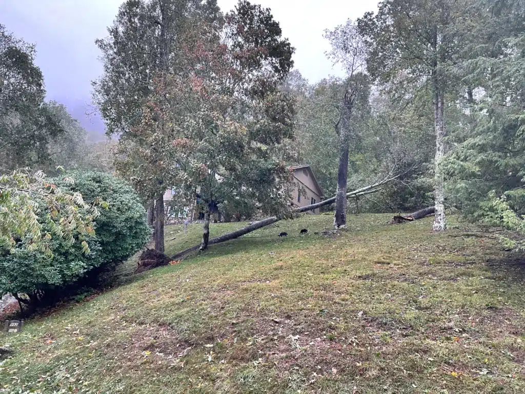
As it began to get a little lighter, we could see one tree in the yard that had been more than 50 feet high snapped about halfway up. Later in the morning we watched an even taller tree just fall over, pulling its roots out of the ground.

Luckily, neither hit the house.
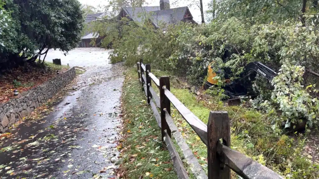
Trees also fell just beyond the end of our driveway, some falling on some equipment being used at a house under construction across the street.
Water leaked in closed windows.
By mid-day it had ended.
We ventured out to investigate. Normally gurgling streams of water were rushing waterfalls; little creeks were rapids. Trees, limbs and leaves covered everything.

How bad was it?
I don’t know how much rain fell or how strong the winds were at our house, but data from weather stations just 20 miles away as the crow flies blew away all records.
“The highest apparent total from the event came from the North Carolina Forest Service’s RAWS station in Busick, with a three-day accumulation of 31.33 inches,” said a blog post by the North Carolina State Climate Office at N.C. State University. “While unvalidated at this point, radar estimates back up the potential for two feet of rain or more in Yancey County.”
For reference, heavily flooded Asheville had some 14 inches of rain.
A RAWS weather weather station is a “Remote Automatic Weather Station.” There are some 2,800 scattered about the U.S., most managed by the National Interagency Fire Center. The Busick station is in Yancey County near Mt.Mitchell at an elevation of 3,058 feet.
The North Carolina State Climate Office’s ECONet weather station on Mt. Mitchell (also in Yancey County) is at an elevation of 6,215 feet and recorded 24.41 inches over the same three-day period. The state Climate Center described that total as “off the charts.”
The National Weather Service said sustained winds speeds of 70 mph were with gusts to 92 mph were recorded at the N.C. ECONet weather station on Mt. Mitchell.
(The North Carolina Environment and Climate Observing Network or ECONet is a network of 45, 10-meter (33-foot) tall aluminum towers in 35 counties in North Carolina and one location in South Carolina. Most are powered by solar with a deep cycle marine battery.)
On Oct. 2, the Weather Service described the initial impact in Yancey County:
Major to catastrophic flooding of streams, creeks, urban areas, and mainstem rivers. The South Toe River Basin and Cane River had dams and rivers surpassing their highest-ever crests by several feet. This likely had major and catastrophic flooding. Widespread wind damage occurred on top of devastating floods.
Widespread trees and powerlines were downed. At least hundreds of homes and businesses were flooded, with many likely destroyed. Widespread road closures, bridges completely wiped out, and roads completely washed away. The extent of landslides are unknown, but pictures and videos would indicate that landslides were very common, especially along steeper slopes. 100% of the county was left without power. The Yancey County water and sewage system was completely destroyed. Numerous water rescues took place as a result of the historic flooding. Communities were essentially cut off from society due to roads being washed away. Several small communities will likely have to be completely rebuilt. Recovery will take months, if not several years in the hardest hit locations.
Two weeks in French Broad Electric shows 37 percent of its Yancey County customers without power.
The same Weather Service impact report said of Madison County (where Marshall is located):
Historic flooding of streams, creeks, urban areas, and mainstem rivers. The North and South Toe River Basin had dams and rivers surpassing their highest-ever crests by several feet. This was likely the most severe flooding in recorded history across Mitchell County. Widespread wind damage occurred on top of devastating floods. Widespread trees and powerlines were downed. At least hundreds of homes and businesses were flooded, with many likely destroyed. Widespread road closures, bridges completely wiped out, and roads completely washed away. The extent of landslides are unknown, but pictures and videos would indicate that landslides were very common, especially along steeper slopes. Almost 100% of the county was left without power and water. Numerous water rescues took place as a result of the historic flooding. Communities were essentially cut off from society due to roads being washed away. Several small communities will likely have to be completely rebuilt. Recovery will take months, if not several years in the hardest hit locations.
No Escape
By Friday afternoon, we decided to go back to Knoxville. We cut enough limbs of the downed trees with a hand limb saw and a lopper and shoveled enough mud off the payment to have a one car wide path out of our street to the main road out of the development, which had been mostly cleared of downed trees.
We head east on I-26 under sunny skies only to be around at the Clear Branch Exit (the Tennessee Welcome Center) because the interstate bridge collapsed in Erwin, Tennessee. We quickly learned that the I-26 and I-40 (and all alternate routes) were closed in all directions in Western North Carolina. Cut-off, we went back to our house, but stopped at the North Carolina welcome center on the trip back.
People were stuck with no way to get from here to anywhere and nowhere else to go. Groups of people stood around chatting, pondering maps (yes, paper maps) and trying to figure out what to do next.
Pulling Together
With no cell service, internet, radio, or TV, information – reliable or otherwise — was scarce. Thankfully, we stumbled on a status being held by the roads and security office in Wolf Laurel and learned they planned to do them every day.
People there also shared what they knew, a restaurant and store brought coffee, Someone showed up with a generator for people to charge their phones. Bottled water was distributed. Food was served.
Volunteer crews from the local fire department cut trees out of roads. Other people were riding around checking on homes and residents.
It became apparent that while we were cut off from the outside world with no power and lots of downed trees, the situation for many others was far worse across a vast swath of the region.
We had food, running water, bottled water and a grill that we used to make coffee, oatmeal, toast, boiled potatoes, steaks, scrambled eggs, hash browns and more.
On Sunday, we were able to get one bar of cell service if you were in just the right spot at the site of the community meetings and were able to notify family we were safe.
Finally, A Route Home
By Sunday evening, the water system’s lines serving our house went dry; the system’s pumps had no power and its storage tanks drained. The water utility, Carolina Water, had already issued a boil water advisory, but a particularly nice-to-have is the ability to flush the toilet.
Out of water and starting to get low on food, we left again on mid-morning Monday. The N.C. Highway Patrol was allowing cars to use “Old Asheville Highway” (Highway 23) from the Wolf Laurel exit on I-26 to Erwin, crossing over I-26 as we came into town with a horrifying panoramic view of the destruction caused by historic flooding of the Nolichucky River that took out the interstate and resulted in several deaths of workers at a plastics factory.
It will be a long rebuild for thousands in hundreds of communities. Find a way to help.
